Cascadia subduction zone
Plate-boundary fault off the Pacific Northwest coast that produces magnitude 9 earthquakes and tsunamis
Plate-boundary fault off the Pacific Northwest coast that produces magnitude 9 earthquakes and tsunamis

The Cascadia subduction zone is a fault about 1,000 km long off western North America, from northern Vancouver Island to Cape Mendocino, California, where ocean floor sinks beneath the North American plate.[1] Its last great earthquake, on 26 January 1700, is estimated at magnitude 8.7–9.2.[5]
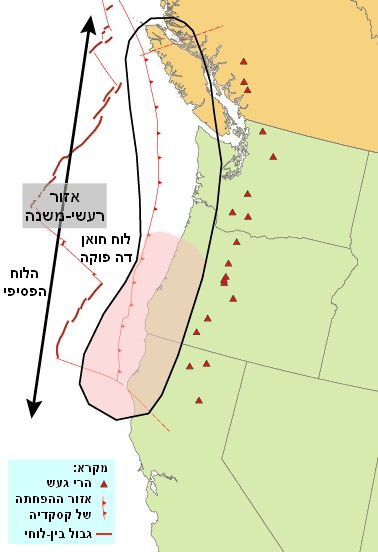
Via Wikimedia Commons: Cascadia subduction zone USGS He by דקי, public domain.
The fault lies mostly offshore, west of Vancouver Island, Washington and Oregon, and extends some distance beneath the Olympic Peninsula.[2] The plate boundary lacked a recognised history of earthquakes, and through most of the 20th century the region was thought incapable of earthquakes larger than magnitude 7.5.[5] Geological work from the 1980s onward, together with Japanese records of a tsunami that arrived without a local earthquake, showed that it has repeatedly produced earthquakes of magnitude 8 to 9 and large tsunamis, and that the most recent one struck in January 1700.[5][6] The date and estimated size of the 1700 earthquake underpin precautions against future earthquakes and tsunamis in the United States and Canada.[5]
The Cascadia subduction zone is a plate boundary: the line along which two of the moving plates of crust and rigid upper mantle that make up the Earth's outer shell meet.[5] The Pacific Northwest Seismic Network (PNSN) describes the Cascadia "megathrust" fault as a 1,000 km plate boundary stretching from northern Vancouver Island, British Columbia, to Cape Mendocino, California, separating the Juan de Fuca and North America plates.[1] The U.S. Geological Survey (USGS) study of the region's undersea sediment records describes the subduction zone as formed by the oceanic Juan de Fuca and Gorda plates sinking beneath the North American plate off northern California, Oregon, Washington and Vancouver Island.[3] The Cascadia Basin, the deep ocean floor above the Juan de Fuca and Gorda plates, extends from Vancouver Island to the Mendocino Escarpment off northern California.[3] At the northern end, off northern Vancouver Island, the small Explorer plate moves independently of both the Pacific and Juan de Fuca plates and converges quite obliquely with the island.[4]
The Juan de Fuca plate is young oceanic crust made at a spreading ridge offshore.[4][1] New crust forms along the Juan de Fuca Ridge, and as fresh, warm crust is produced, older, cooler and denser crust is moved away from the ridge.[1] The Juan de Fuca plate is the remnant of a much larger plate that has mostly disappeared beneath North America over about 150 million years of subduction.[5]
Convergence, the rate at which the plates close on each other, is a few centimetres a year. PNSN gives about 4 cm per year.[1] The USGS book The Orphan Tsunami of 1700 states that by the early 1980s geophysicists had shown the Juan de Fuca plate was subducting at an average of 4 metres per century.[5] A 2007 GPS study by Robert McCaffrey and colleagues, citing earlier work by Wilson (1993), gives a rate that increases northward from 30 to 45 mm per year, with oblique convergence along the Oregon coast and convergence more nearly head-on off Washington and Vancouver Island.[4] Goldfinger and colleagues (2012) give about 35–38 mm per year at the latitude of Oregon.[3]
Subduction is the process in which one tectonic plate is thrust beneath another. Natural Resources Canada explains that the Juan de Fuca and North American plates move continuously towards each other but become "stuck" where they are in contact; when the built-up strain exceeds the friction between them, the fault slips in a very large earthquake.[2] Such an earthquake on the boundary fault of a subduction zone is called a megathrust earthquake, and PNSN states that subduction zone megathrusts are the only faults on Earth that can produce earthquakes larger than magnitude 8.5.[2][1]
The fault does not behave the same way at every depth. According to PNSN, at depths shallower than about 30 km the two plates are locked together by friction, and strain (deformation of the rock) slowly builds there.[1] Immediately below the locked part is a transition zone that moves in "slow slip events", slipping a few centimetres about every dozen months; below that, GPS measurements suggest the fault slides continuously and silently at the long-term plate rate.[1] From the fault's surface trace on the sea floor down to a depth of perhaps 5 km, observations are scarce, and PNSN states that it is not known whether that shallow part is stuck or slipping.[1] A 2007 analysis of GPS data found the subduction fault locked mainly offshore, except in central Oregon, where locking extends inland.[4] Natural Resources Canada has determined that the nearest part of the locked portion is only about 75 km from Victoria, British Columbia.[11]
When a locked megathrust slips, the leading edge of the overriding plate breaks free and springs seaward and upward, while behind it the plate stretches and its surface falls.[5] Such sudden lowering of the coast puts marshes and forests within reach of the tides, and it became one of the main kinds of evidence for Cascadia's earthquake history.[5] Natural Resources Canada expects the west coast of Vancouver Island to drop by as much as a metre or two in the next megathrust earthquake.[2] The sudden vertical movement of the sea floor also displaces a large volume of water, which spreads outward as a tsunami.[2]
Cascadia poses more than one kind of earthquake threat. The subducting Juan de Fuca plate itself produces earthquakes as large as magnitude 7, faults in the overriding North American plate can produce large earthquakes, and the plate-boundary fault can produce great earthquakes of magnitude 8 or 9.[5] Natural Resources Canada notes that inland earthquakes, though smaller, are closer to cities and more frequent, and in its questions and answers on British Columbia's megathrust hazard it calls them "our biggest earthquake hazard".[2] A megathrust earthquake would be about 150 km from Vancouver; its shaking could last several minutes, and the long duration can damage buildings that would survive the same strength of shaking in a shorter earthquake.[2]
Outsiders scarcely knew north-western North America in 1700. European geographers left the north-west coast of North America blank on their maps, and the coast from Alaska to Oregon's Cape Blanco was not charted until Spanish and English expeditions of the 1770s.[5] Early explorers, including the Lewis and Clark Expedition on the Columbia River in 1805 and 1806, recorded no signs of Pacific coast earthquakes or tsunamis.[5]
The oral traditions of the region's Indigenous peoples, however, tell of flooding from the sea. The Orphan Tsunami of 1700 reproduces one of the first such accounts to be written down, from the diary of James Swan at Neah Bay, Washington Territory, for 12 January 1864.[5] Swan's informant, the Makah leader Billy Balch, described a flood in the "not very remote" past in which the water receded for four days, then rose and covered all but the highest ground, stranded canoes in trees and caused "numerous" deaths, and said the same happened at Quileute.[5] The account mentions no earthquake, and the book's authors leave open whether it describes a local or a distant tsunami.[5] Satake and colleagues noted in 1996 that their estimated timing was consistent with Native American legends that an earthquake occurred on a winter night.[6]
Along the Pacific coast of southern Washington stand ghost forests: groves of dead, weathered trunks in tidal marshes, composed entirely of western red cedar.[5] They were first documented in the early 1850s; the naturalist James Graham Cooper, who wintered at Shoalwater (now Willapa) Bay in 1853–1854, attributed their death to gradual sinking into quicksand.[5] Geologists now attribute it to sudden lowering of the land during an earthquake.[5] Thousands of stumps, mainly of Sitka spruce, are also exposed in the banks of tidal streams in southern Washington, with hundreds more at estuaries in Oregon and northern California, and buried marsh soils lie abruptly beneath tidal mud in streambanks and sediment cores.[5]
In the late 1980s, prompted by the debate over Cascadia's earthquake potential, geologists examined bays and river mouths along the coast and found evidence that the land had dropped at nearly every one.[5] At some sites the buried soils are capped by sand carried in by a tsunami or forced up through cracks by shaking-induced liquefaction (the loss of strength in wet, loose sand during shaking).[5]
Tree rings narrowed the date. Starting in 1987, scientists sampled red-cedar trunks standing in tidal wetlands of four Washington estuaries and matched their ring-width patterns with those of old trees that had survived on higher ground.[5] In 1996, bark-bearing roots were dug up so that each tree's final ring could be dated; seven of eight trees died after completing the 1699 growing season and before the start of the next, in the window between August 1699 and May 1700.[5] This work, published in 1997, strengthened the link to the Japanese tsunami.[5]
In January 1700 unusual waves came ashore along Japan's Pacific coast without any earthquake being felt there.[5] Written records by samurai, merchants and peasants describe flooded fields, wrecked houses, a fire, a shipwreck, evacuation and fright, and some writers called the flooding a "high tide" rather than a tsunami.[5] At Kuwagasaki, next to Miyako, 13 houses were destroyed by flooding and 20 more by a fire that broke out at the same time; near Nakaminato, two sailors were killed and nearly 30 tons of rice sank in a shipwreck caused mainly by a storm; and around Tanabe, rice paddies and wheat crops were lost.[5] Lacking a known parent earthquake, it has come to be called the "orphan tsunami", probably a modern term of North American origin.[5]
In a paper in Nature published on 18 January 1996, Kenji Satake, Kunihiko Shimazaki, Yoshinobu Tsuji and Kazue Ueda reported several tsunami records in Japan from 1700 with no sign of a local cause.[6] They found no large earthquake in 1700 in South America, Alaska or Kamchatka, leaving Cascadia as the most likely source, and estimated the time of the earthquake as about 21:00 local time on 26 January 1700.[6] From the tsunami heights in Japan they estimated a magnitude of 9, which would mean the earthquake ruptured the entire length of the subduction zone.[6] The reasoning on timing is that the tsunami took about ten hours to cross the Pacific to northern Honshu; allowing for the time-zone difference, waves that reached Kuwagasaki around midnight place the earthquake at about 9 p.m. Cascadia time on Tuesday, 26 January 1700.[5]
The USGS book on the orphan tsunami, by Brian Atwater, Satoko Musumi-Rokkaku, Kenji Satake, Yoshinobu Tsuji, Kazue Ueda and David Yamaguchi (first edition 2005, second edition 2015), gives an estimated magnitude of 8.7 to 9.2.[5] It describes a rupture of at least 1,000 km of the plate boundary, about the length of Honshu, with the plates probably lurching past one another by about 20 metres on the seaward half of the rupture.[5] The tsunami model used in the book assumes a magnitude 9.0 earthquake with a fault rupture 1,100 km long.[5] PNSN likewise gives an estimated magnitude between 8.7 and 9.2.[1]
In a 1987 paper in Science, Brian Atwater reported that intertidal mud had buried vegetated lowlands in westernmost Washington at least six times in the past 7,000 years, each burial probably caused by rapid tectonic subsidence of 0.5 to 2.0 metres, and that sand sheets on at least three of the buried lowlands suggested tsunamis.[7] At one Washington site described in the 2015 USGS book, the sequence records seven earthquakes in the past 3,500 years; the six intervals between them average about 500 years but range from a few centuries to a millennium.[5]
Earthquakes also shake loose sediment on the continental slope, which pours down submarine canyons as dense, bottom-hugging flows of muddy water called turbidity currents; the layers they leave on the deep sea floor are called turbidites.[5][2][3] In USGS Professional Paper 1661-F (2012), Chris Goldfinger and twelve co-authors analysed sediment cores from Vancouver Island to Cape Mendocino and tested whether turbidites in separate channel systems were laid down at the same time, which would point to a single regional trigger such as a great earthquake.[3] They identified 19 Holocene turbidites (those of roughly the past 10,000 years) in Cascadia Channel and its tributaries; the oldest averages about 9,800 calibrated years before present and the youngest about 270, indistinguishable from the 1700 earthquake.[3] The northern record gives a great-earthquake recurrence of about 500–530 years.[3]
The same study proposed three modes of rupture over the past 10,000 years: 19–20 full-length or nearly full-length ruptures; three or four ruptures of the southern 50–70 percent of the margin; and 18–20 smaller ruptures of the southern margin alone.[3] Counting all 41 events, the average recurrence for the southern margin is about 240 years.[3] The authors also found a pattern of clustering, with four or five cycles of two to five earthquakes separated by unusually long intervals.[3]
Other summaries use different counts and time spans. Natural Resources Canada states that 13 megathrust events have been identified in the last 6,000 years, an average of one every 500 to 600 years, with some as close as 200 years apart and some as far apart as 800 years.[2] PNSN states that geological evidence shows at least 19 great earthquakes (magnitude 8 or larger) over about the past 10,000 years, with an average recurrence of about 500 years, including both full-margin ruptures of about magnitude 9 and partial ruptures of about magnitude 8.[1]
Probability figures depend on the method used and the part of the margin considered. Goldfinger and colleagues (2012) estimated time-independent probabilities of 7–12 percent in 50 years for full or nearly full margin ruptures and about 21 percent in 50 years for a southern-margin rupture; their time-dependent estimates were similar for the north (about 7–12 percent) and 37–42 percent in 50 years for the southern margin.[3] The 2002 U.S. national seismic hazard maps, as summarised in the USGS orphan-tsunami book, used a mean recurrence of 520 years and a median of 440 years for great Cascadia earthquakes, giving a probability of about 10 percent in 50 years.[5] As of November 2026, PNSN's Cascadia page states that the USGS estimates a 10–15 percent chance of a full-margin earthquake of about magnitude 9 in the next 50 years.[1]
A Cascadia earthquake would send a tsunami both across the Pacific and onto the nearby coast within minutes. The orphan-tsunami book notes that before the 1980s any tsunami striking the region was expected to come from far away, leaving hours for warning; by the end of the century Cascadia was recognised as a source of tsunamis that would reach its shores in a few tens of minutes.[5] Washington's Emergency Management Division stated in November 2021 that, after a large Cascadia earthquake, people on the outer coast may have only 10 to 15 minutes after the shaking stops to reach high ground.[14] Studies cited by the same agency found that residents of Puget Sound would have at least an hour.[14]
Oregon's Department of Geology and Mineral Industries (DOGAMI) maps Cascadia tsunami inundation in five scenarios labelled like T-shirt sizes (S, M, L, XL and XXL), first produced in 2013; communities typically use the XXL, "maximum-considered", zone for evacuation planning.[19]
Two studies have modelled how far a Cascadia tsunami would travel up the Columbia River.
A study by David Hill, an associate professor of civil engineering at Oregon State University, and graduate student Kirk Kalmbacher, published in the Journal of Waterway, Port, Coastal and Ocean Engineering and announced by the university on 19 February 2015, simulated a Cascadia earthquake and tsunami under different river flows and at high, low, flood and ebb tides.[12] It found that tidal stage matters far more than river flow, that the effect would be greatest at the highest tides of the year, and that the tsunami would be largely dissipated within about 50 miles (80 km) of the river mouth, near Longview, Washington.[12] For a magnitude 9.0 earthquake at the highest tide of the year, the study estimated water-level rises of about 13 feet (4 m) just inside the mouth, about 10 feet at river mile 6 near Hammond, Oregon, about 6.6 feet at river mile 12 near Astoria, about 1.6 feet at river mile 25 near Welch Island, and no measurable rise at river mile 50 near Longview.[12] Increases around Portland and Bonneville Dam would be "almost immeasurable".[12]
DOGAMI Special Paper 51, Columbia River Tsunami Modeling: Toward Improved Maritime Planning Response (2018), by Jonathan Allan, Joseph Zhang, Fletcher O'Brien and Laura Gabel, ran 35 simulations combining dynamic tides, different river flows and four earthquake scenarios, two distant (Alaska) and two local Cascadia scenarios.[13] For its maximum-considered Cascadia scenario (XXL1), the report states that the tsunami reaches the mouth of the Columbia in as little as 7 minutes, Ilwaco after 25 minutes, Warrenton after 31 minutes, Tongue Point after 46 minutes and Wauna after about 99 minutes.[13] It is detectable upriver as far as the confluence of the Columbia and Willamette rivers, arriving 4 hours 40 minutes after shaking begins, but carries little energy upriver of St. Helens; the report concludes it would not affect the ports of Portland or Vancouver, apart from the effects of the earthquake shaking itself.[13] On the open coast, maximum water levels in this scenario exceed 18 m (60 ft) at Seaside, and at the river mouth they range from 6 to 12 m above mean higher high water.[13] Currents exceeding 6.1 m per second (12 knots) are modelled across much of the lower estuary west of Astoria, and they fall below the 1.5 m per second (3-knot) threshold for port damage by the time the tsunami reaches Wauna.[13]
The two studies broadly agree that the hazard is concentrated in the lower estuary and that the effect on water levels at Portland would be negligible. They differ in emphasis: the Oregon State release reports water-level rise at points along the river, while the DOGAMI report also tracks currents and the furthest point at which the wave can be detected at all.[12][13] The DOGAMI report found that tsunamis arriving at the slack water of a flood tide penetrated furthest upriver, that ebb-tide arrivals produced considerably stronger currents at the river mouth, and that varying river discharge made little difference to currents.[13]
Below the locked zone, the plate boundary slips in recurring episodes that are too slow to be felt as earthquakes. Beginning in 1991, Natural Resources Canada scientists Herb Dragert and Garry Rogers installed one of the first permanent GPS networks in North America on Vancouver Island and found repeated episodes of slow fault slip, each lasting about two weeks.[11] In a 2003 paper in Science, Rogers and Dragert reported that these slow slip events, at first thought to be silent, coincide in time and place with tremor-like seismic signals, with little or no tremor between slips.[9] They named the combination episodic tremor and slip (ETS) and proposed that it could serve as a real-time indicator of stress loading on the Cascadia megathrust.[9]
Natural Resources Canada describes the effect at the surface as a cycle that moves Vancouver Island about one centimetre toward the British Columbia mainland over roughly 14 months, then several millimetres back in about two weeks.[11] PNSN reports ETS episodes from British Columbia to northern California, explains tremor as tiny vibrations radiated while the slow slip is under way, and monitors it continuously.[10] Each episode relieves stress on the deeper part of the plate boundary but adds stress to the locked part above it.[1]
Until the 1980s there was little reason in the written or instrumental record to expect great earthquakes at Cascadia. Plate tectonics, developed in the 1960s, identified the Juan de Fuca plate as a remnant of a larger subducting plate, and by the early 1980s geophysicists had shown it was still subducting, but there was no consensus on how the plates moved past each other.[5] In 1984 Thomas Heaton and Hiroo Kanamori pointed out that, despite good evidence of present-day convergence, there had been remarkably little historical earthquake activity on the shallow part of the subduction zone; they could not rule out slow aseismic creep, but found that the zone shared many features with subduction zones that had produced great earthquakes.[8] In 1986 Heaton and Hartzell proposed that Cascadia might produce earthquakes as large as the 1964 Alaska and 1960 Chile earthquakes.[5]
Field evidence followed. Atwater's 1987 report of repeatedly buried coastal lowlands in Washington was followed in the late 1980s by findings of subsidence at bays and river mouths along the coast.[7][5] In the early 1990s, two lines of evidence showed that the subsidence had accompanied strong shaking: turbidity currents offshore and sand that had liquefied and erupted through cracks onshore.[5] What remained unknown was whether the fault broke all at once in a magnitude 9 earthquake or piecemeal in a series of smaller ones.[5] Satake and colleagues' 1996 analysis of the Japanese records, the 1997 tree-ring dates, and improved tsunami and earthquake modelling in 2003 together supported a single great earthquake on 26 January 1700.[6][5]
According to the USGS orphan-tsunami book, building codes in Washington and Oregon did not begin to reflect the great-earthquake threat until 1994, when the Uniform Building Code extended its high-hazard seismic zone 3 throughout western Washington and western Oregon.[5] More than half of the region's nearly 900 high-rise buildings had been completed by 1990.[5] The 2002 U.S. national seismic hazard maps gave equal weight to a magnitude 9 rupture about 1,000 km long and to magnitude 8.3 ruptures about 250 km long; in Canada, great Cascadia earthquakes were included in hazard mapping for the proposed 2005 national building code.[5]
In Oregon, Senate Bill 379, passed in 1995, limited the construction of certain essential and special-occupancy facilities, such as hospitals, schools and fire and police stations, inside a regulatory tsunami inundation line drawn by DOGAMI.[18][19] In 2019 the legislature passed House Bill 3309, effective 1 January 2020, which turned the prohibited uses into uses that require consultation with DOGAMI before design plans are submitted, with no requirement to follow DOGAMI's suggested mitigation.[19]
ShakeAlert is the USGS earthquake early warning system for the U.S. West Coast, developed with partners over 15 years; it is designed to give people seconds to take protective action before strong shaking arrives.[15] It relies on sensor data from the Advanced National Seismic System, and since late 2018 its data have been used to trigger automated actions such as slowing trains, opening firehouse doors and closing valves.[15] Public alerts to mobile phones began in California in 2019 and expanded to Oregon in March 2021; on 4 May 2021 the USGS announced that the rollout to Washington completed the West Coast system, available to more than 50 million people.[15]
Along much of Washington's outer coast it can take an hour or more to walk out of the tsunami inundation zone, and some communities are built on low sandy spits without natural high ground.[14][16] USGS geographer Nathan Wood worked with Washington emergency managers on models of pedestrian evacuation times that communities used to plan vertical evacuation structures, which are buildings or berms tall and strong enough to serve as refuges.[16] One was built at Ocosta Elementary School near Westport, Washington, which the USGS describes as the first tsunami-safe school building in the United States, after voters approved a $13.8 million school bond; its rooftop platform stands nine metres above the ground on piles driven 15 metres into the sand and has room for as many as a thousand people.[5][16] A November 2021 state assessment concluded that dozens more are needed: between 25 and 40 in Pacific County, 30 to 42 in Grays Harbor County and one to three in Clallam County.[14]
Cascadia Rising 2016 was a functional exercise held on 7–10 June 2016, sponsored by FEMA Region 10 and the emergency management agencies of Washington, Oregon and Idaho.[17] Its scenario was a magnitude 9.0 earthquake along the full length of the subduction zone, with tsunamis and aftershocks affecting Washington and Oregon.[17] More than 20,000 people from local, state, federal, tribal, military and non-governmental organisations took part, and the joint after-action report called it the Pacific Northwest's largest multi-state functional exercise.[17] A follow-up series, Cascadia Rising 2022, was held with tabletop exercises on critical transportation and mass care.[20]
 Get Micwyn on your home screenIts own icon, full screen, and notifications.